Recommended Dock Standards for Peconic Bay and Gardiners Bay
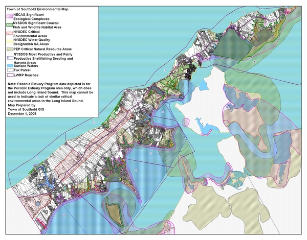
The Dock moratorium expired again on Feb. 19 and the Planning Board Office has put out a one page standard for the construction of docks in Peconic Bay and Gardiners Bay. I FOILED the map overlays so we can see them on this site on Thurs. 3/12.
The standard will NOT allow you to apply for a dock permit if your property happens to be in an area defined as a “Northeast Coastal Area Study Significant Coastal Habitat” and a “NYSDEC Significant Coastal Fish and Wildlife Habitat Area.” It’s my guess these two areas encompass 95% of the Peconic Bay system, but that’s why we need to see the maps which are being emailed to me by Scott Hillary as soon as the FOIL request is approved.
So if you are in these to areas, you cannot build a dock if your property is also in any two or more of the following designated areas:
1.NYSDEC Critical Environmental Area. You can request a beach or area that you don’t own, be so designated because you enjoy the view or saw a deer or piping plover. this too probably encompasses most of the bay, but we will wait to see the map.
2.NYSDEC water quality designation:S/A This means the water is saline and acceptable. I think it would be hard to find an area of Peconic Bay that is not.
You can go to the NYSDEC website and find the definitions for these designations above.
3. Peconic Estuary Program Critical Natural Resources Area. Again, you can request this designation be put on someone elses property.
4. Fairly productive and Most productive Shellfishing, Seeding, and Harvest Areas.
So if you are in the first two areas and you have two out of the four above designations, you are out of luck. You have to see the maps that make this clear. It has taken over 6 months to come up with these defining areas to preclude docks so they must be all encompassing.
If, you somehow have property so undesirable, unsightly, and environmentally impaired as to not be excluded by the above, then you can build, IF:
You build a dock that reaches 4′ of water at MLW, but you can’t exceed 80′ to do so. And you can dredge to reach 4′, so it sounds like maintenance dredging will never be permitted. There are very specific points in this dock standard as to how 4′ is measured: from the center point at the end of the dock; 15′ seaward of that point; 15′ landward of that point and 15′ 90 degrees to each side from the center point at the end of the dock. And, your property is not in a FEMA zone “V”.
Now this is so contrived that I am pretty sure all 654 potential dock sites sited in the standard will not qualify to meet this standard, either by the designations gauntlet or the depth test. Do you think they spent over 6 months preparing a standard where all 654 would be allowed? No. Half? No. A quarter? No. 5% ? No. Think about it. In Southold’s 369 year history we only have a total of 41 docks that are so offensive that the planning board together with help from the NYS Dept of State has been working for at least a year to stop the spread of this terrible scourge.
Meanwhile the moratorium has expired again and there are STILL no applicants waiting in the wings to build a dock….
I will post the map overlays as soon as the FOIL request is approved so you can judge for yourself if this new standard is a standard by which one can build a dock, or just a series of contrivances to prohibit the construction of a dock.
And here is a prediction: the next step will be a standard for the construction of docks…..(GUESS WHERE????) It’s all about control folks, just keep paying your taxes and keep quiet.
That’s my opinion,
John Kramer
Editor’s Note: The map is a very large 4MB file, so clicking the reduced file image below will take you to a separate link to download the original file, which you can then zoom in sufficiently close to identify individual properties.


Comment ( 1 )