


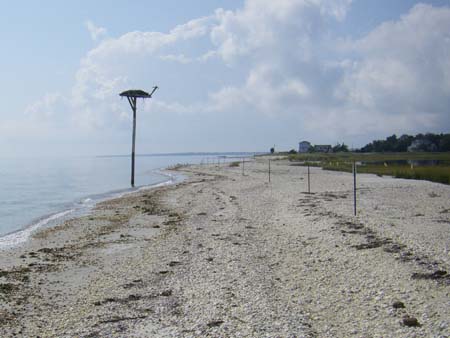
Osprey pole at Cedar Beach, no longer on land
Some years ago the osprey pole pictured here was 50 feet inland. Today at high tide it is 15 feet out in Peconic Bay. What has happened? Obviously the sand has washed away. That is because the Southeastern face of Great Hog Neck forms a race with Jessup’s neck on the South Fork and a swift tidal rip forms, with currents of several knots pushing the sand around. The entrance to Cedar Beach inlet is artificially placed in a 1923 construction which envisioned a large community of building lots around the creek. The plans stalled in the great depression, but the re-location of the creek’s inlet from the northeastern face to the southeastern face created an unstable inlet by virtue of its opposition to Jessup’s Neck. The routine maintenance dredging required to keep the artificial entrance open used to provide beach re-nourishment that kept Cedar Beach from washing completely away. A change in the way dredging spoil is handled results in the sand being piled upland of the water’s edge, providing no replenishment to the eroding beach. Currently the beach is no more than 100 ft. wide where the Osprey pole is located. A good nor’easter may well breach the narrow strip of sand.

Old entrance to Cedar Beach harbor, now used by the Cornell Marine Center
What happened to the original inlet? It has been commandeered by the Cornell Marine Laboratory and is used to moor their boats and to provide a source of water for their experimental tanks. Here is the original creek entrance, far removed from the turbulence of the Cedar Beach Point – Jessup’s Neck race. That is the Cornell Marine Center in the background.
No Comments